After getting 4.3 inches of snow on Easter Sunday, the Danville area may be in for some severe thunderstorms on Tuesday. The National Weather Service says thunderstorms are possible Tuesday ahead of a cold front, and some of the storms may become severe Tuesday afternoon.


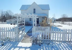
[This snow at Kennekuk County Park will likely disappear quickly. Temperatures are expected to climb into the low-sixties on Tuesday, but Wednesday’s high is only expected to be around 40. Note: You can click on the photos to enlarge them.]
But there is only a slight chance of severe thunderstorms, mainly across east-central and southeast Illinois. Damaging wind gusts are the primary threat, but hail and an isolated tornado are also possible.
Meanwhile flood warnings continue along the Wabash River.
The National Weather Service in Lincoln says in addition to the 4.3 inches of snow that fell on Danville Sunday other areas were also hit by the surprise snowstorm.
Some snow totals from Sunday included:
- 5 inches near Homer
- 3 inches at Hoopeston
- 1 inches at Ogden
- 5 inches at Farmer City
- 5 inches at Philo
- 6 inches at Decatur
- 6 inches at Purdue University in Lafayette
[** The photos were taken Monday, April 2, 2018, at Kennekuk County Park.]